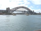
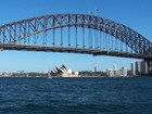
Sydney Harbour Bridge Photographs
Home > Australian Photos > Sydney Harbour Bridge
(Click on an image to view a Larger Picture)
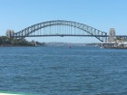
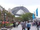
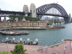
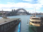
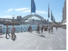
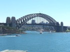
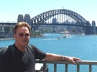
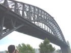
- These images are protected by copyright. They may not be copied for use elsewhere.
- I used a Kodak DX6490 4.0 mega pixel digital camera to photograph these images.
Sydney Harbour Bridge
From Wikipedia, the free encyclopaedia
The Sydney Harbour Bridge is one of the major landmarks of Sydney, Australia, connecting the Sydney Central Business District (CBD) with the North Shore commercial and residential areas, both of which are located on Sydney Harbour. The dramatic water vista of the bridge together with the nearby Sydney Opera House is a popular iconic image of both Sydney and Australia.
The bridge has often called "The Coathanger" by Australians on account of its arch based design.
The Sydney Harbour Bridge was the city's tallest structure until 1967.
One source of disappointment for those who had built the bridge was the discovery that the Bayonne Bridge in the United States, opened on November 15, 1931, was 70 cm longer. However, that fact was not generally known, and millions of Australian school children throughout the next 50 years were taught, erroneously, that the Sydney Harbour Bridge was the world's longest single-arch bridge. However, it remains the world's largest (but not the longest) steel arch bridge.
Description
The bridge's two ends are located in at Dawes Point (in Sydney's Rocks area) and Milsons Point (in Sydney's lower North Shore area). It carries 6 lanes of road traffic on its main roadway, 2 lanes of road traffic (formerly 2 tram lines) and a footpath on its eastern side, and 2 railway lines and a bicycle path along its western side. At 48.8m wide, it is listed by Guinness World Records as the widest bridge in the world.
The road carried across the bridge is known as the Bradfield Highway and is about 2.4 km long, making it one of the shortest highways in Australia. (The shortest, also called the Bradfield Highway, is found on the Frank Jolly bridge in Brisbane). The bridge deck portion of the highway is 1.149 km long. It is concrete and lies on trimmers (beams that run along the length of the bridge). The trimmers themselves rest on steel beams that run along the width of the bridge. The trimmers and beams are visible to boats that go underneath the bridge.
The arch is composed of two 28-panel arch trusses. Their heights vary from 18 metres (at the center of the arch) to 57 metres (besides the pylons). The arch span is 503 metres and the weight of the steel arch is 39,000 tons. The arch's summit is 134 m above mean sea level, though it can increase by as much as 18 cm on hot days as the result of steel expanding in heat. Two large metal hinges at the base of the bridge accommodate these expansions and contractions and thereby prevent the arch from being damaged.
The two pairs of pylons at each end are about 89 metres high and are made of concrete and granite. A museum and tourist centre with a lookout of the harbour can be found in one of the southern pylons. Abutments - which support the ends of the bridge - are contained at the base of the pylons. They prevent the bridge from stretching or compressing due to temperature variations.
The steel used for the bridge was largely imported. About 79% came from Britain, the rest was Australian-made. The granite, quarried in Moruya New South Wales, and concrete is also Australian.
The total weight of the bridge is 52,800 tonnes, and six million hand-driven rivets hold the bridge together.
Access
Motor vehicle access to the bridge is normally done through York Street, Sydney or via the Cahill Expressway. A bridge toll is payable at the tollgates on the southern end of the bridge. Drivers on the northern side will always find themselves on the Warringah Freeway, though it is easy to turn off the freeway to drive westwards into North Sydney or eastwards to Neutral Bay and beyond upon arrival on the northern side.
Pedestrian access from the northern side is easy and involves climbing an easily-spotted flight of stairs at Milsons Point. Pedestrian access on the southern side is more complicated, but signposts in the Rocks area now direct pedestrians to the long and sheltered flight of stairs that lead to the bridge's southern end. These stairs are located near Gloucester Street and Cumberland Street in the Sydney Rocks area.
The bridge lies between Milson's Point and Wynyard railway stations, located on the north and south shores respectively. Both are part of the North Shore line.
History
Planning
There had been plans to build a bridge as early as 1815, when Francis Greenway proposed that a bridge be built across the harbour. Nothing came of this.
The building of the current bridge can be said to have started in 1890, when a royal commission determined that there was a heavy level of ferry traffic in the Sydney Harbour area, best relieved with the construction of a bridge. Vehicular access to the north shore was undertaken with a series of smaller bridges located further westwards in the harbour, but this was insufficient for the traffic in the Sydney/North Sydney area.
Designs and proposals were requested in 1900, but a formal proposal was not accepted until 1911. In 1912, John Bradfield was appointed chief engineer of the bridge project, which also had to include a railway. He completed a formal design - the now familiar single arch shape - in 1916, based in part on the Hell Gate Bridge, a railroad bridge in New York City, but plans to implement the design were postponed until 1922, primarily because of World War I.
In November, 1922, the NSW parliament passed laws that allowed the bridge's construction. Construction tenders for the bridge were requested the same year, and a British firm called Dorman Long and Co Ltd won. To offset concerns about a foreign firm participating in the project, assurances were given by Bradfield that the workforce building the bridge would all be Australians.
Construction
The building of the bridge, under the management of Bradfield, coincided with the construction of a system of underground railways in Sydney's CBD, known today as the City Circle, in the late 1920s, and the bridge's required rail link was designed with this in mind.
Two other persons were involved in the bridge's design and construction. Laurence Ennis, the engineer-in-charge at Dorman Long and Co was the main supervisor. Bradfield visited occasionally throughout the project, and in particular at the many key stages of the project, to inspect progress and make managerial decisions. Sir Ralph Freeman was hired by the company to design the accepted model in further detail. Later a bitter disagreement broke out between Bradfield and Freeman as to who actually designed the bridge in the end. Another name connected with the bridge's design is that of Arthur Plunkett.
The construction project itself began in 1923, with the demolition of 800 homes. The owners of these homes received compensation, but their occupants did not.
The first stage of the bridge project was the building of two work sheds at Milson's Point to assist in building the bridge - the light and heavy workshops. Their purpose was to build the bridge's many parts.
The first sod for the bridge was turned that same year. In January 1925, the excavations to build the abutments and approach spans began. In October 1925, the building of the abutments and approach spans themselves began, and these were completed in September 1928. Construction of the bridge itself began in December 1928, with the construction of the bridge parts in the workshops.
Construction of the arch of the bridge began in 1929, with two separate teams building the arch on each side using creeper cranes. The first panel was erected on the southern side in March, 1929. The southern end of the bridge was always worked on a month ahead of the northern end, in order to detect any errors and to ensure that they did not happen on the northern side.
The arch was successfully joined on the afternoon of 19 August 1930. Ennis and four associates personally witnessed this whilst standing on top of the bridge. Following a parting that occurred due to the contracting of metal in the evening, the ends were rejoined at 10 pm, and have remained joined since then.
The road, two sets of tram lines and railways were completed in 1931. On 19 January 1932, the first train, a test steam locomotive, safely crossed the bridge. About 90 others also crossed the bridge in the months that followed.
The construction work sheds were demolished after the bridge was completed, and the land that they were on is now occupied by Luna Park and the North Sydney swimming pool.
The standards of industrial safety during construction were inadequate. 16 workers died during construction, mainly from falling off the bridge. Several more were injured from unsafe working practices undertaken whilst heating and constructing its rivets, and deafness experienced by many of the workers in later years was blamed on the project.
Opening of the Bridge
The bridge was formally opened on 19 March 1932. The opening itself became an event in its own right.
Amongst those who attended and gave speeches were the State Governor, Sir Philip Game, the Minister for Public Works, and Ennis.
The Premier of NSW, Labor politician Jack Lang, intended to formally open the bridge by cutting a ribbon at its southern end. However, just as he was about to do so, a Captain Francis de Groot moved forward on a horse and slashed the ribbon with a sword, declaring the bridge to be open instead. He was promptly arrested and later convicted of offensive behaviour. The ribbon itself was hurriedly retied and Lang performed the opening ceremony. After he did so, there was a 21-gun salute and a RAAF fly-past.
It was later revealed that de Groot was not a member of the regular Army but that he was a member of a 1930s right-wing paramilitary group called the New Guard, opposed to Lang's leftist policies. He had been impersonating a member of the military present that day on the bridge. The incident itself was one of several that Lang had with the New Guard in that year.
A similar ribbon-cutting ceremony on the bridge's northern side by North Sydney's mayor, Alderman Primrose, was carried out without incident. It was later discovered that Primrose was also a New Guard member, but his role in and knowledge of the de Groot incident, if any, is unclear.
A message from a primary school in Tottenham, 550 km away in rural NSW, arrived at the bridge on the day and was presented at the opening ceremony. It had been carried all the way from Tottenham to the bridge by relays of school children, with the final relay being run by two children from the nearby Fort Street Boys' and Girls' school.
Other features of the opening ceremony included a vast display of floats and marching bands - one quite remarkable by Depression standards. The public was allowed to walk on the highway.
There had been numerous preparatory arrangements. On 14 March 1932, three postage stamps were issued to commemorate the imminent opening of the bridge. One of these stamps, with a face value of five shillings, is now worth several hundred dollars today.
Several songs were also composed in advance for the occasion. These have now been largely lost or forgotten.
The bridge itself was regarded as a triumph over Depression times.
Post-construction
Since the opening, the bridge has been the focal point of much tourism and national pride. It is Sydney's focal point of New Year and Australia Day celebrations, with fireworks being set off from the arch. Tragically, it has also been the scene of about 40 suicides, many of which took place within months of the bridge's opening.
In 1958, the two tram lines were removed and two extra lanes of roadway created. These lanes are now the southbound lanes of the Cahill Expressway.
In 1982, the bridge celebrated the 50th anniversary of its opening. Once again, the bridge was closed to vehicles and pedestrians allowed full access for the day.
Australia's bicentennial celebrations on 26 January 1988 attracted large crowds in the bridge's vicinity. In that same year, work began to build an underground tunnel to complement the bridge. It was determined that the bridge could no longer support the increased traffic flow of the 1980s. The Sydney Harbour Tunnel was completed in August, 1992. It is intended only for use by motor vehicles. Before it was officially opened for use, the tunnel was made open for pedestrian access, with persons on that day able to walk down the tunnel's roadway.
In May, 2000, the bridge was closed to vehicular access for a day to allow a special reconciliation march - the "Walk for Reconciliation" - to take place. This was part of a response to an Aboriginal "Stolen Generation" inquiry, which found widespread suffering had taken place amongst Australian Aboriginal children forcibly placed into the care of white parents in a little-publicised government scheme. A large number of Australians walked the Bradfield Highway in a symbolic gesture of crossing a divide.
During the Sydney 2000 Olympics in September and October 2000, the bridge was adorned with the Olympic Rings. It was included in the Olympic torch's route to the Olympic stadium. The men's and women's Olympic marathon events likewise included the bridge as part of their route to the Olympic stadium. A massive fireworks display at the end of the closing ceremony ended at the bridge.
Security on the bridge has recently been introduced. It has been deemed likely that the bridge will attract the attention of terrorists because of Australia's support of the War on Terrorism.


