Interactive New South Wales Map
Explore New South Wales with an interactive map featuring Street View, satellite and terrain views. Live weather, local news and location details for New South Wales — built for travel planning and emergencies.
Map search is available for a limited number of queries per session to manage costs. Be specific — search precisely for best results.
| State | New South Wales (NSW) |
| Capital | Sydney |
| Largest City | Sydney |
| Country | Australia |
| Nickname | The Premier State |
| Latitude | -32.841 |
| Longitude | 150.5048 |
| Population | 8,072,163 |
| Cities & Towns | 4,621 |
| Area | 800,642 km² |
About New South Wales
New South Wales unfurls a tapestry of dramatic landscapes, from the sapphire kiss of the Pacific along its eastern seaboard to the dusty ochre heartlands stretching towards the vast interior. Majestic mountain ranges, the Great Dividing Range a formidable spine, cradle ancient rainforests and give rise to vital rivers that nourish the plains below. The coast itself is a masterpiece of sculpted sandstone cliffs, golden beaches that shimmer under an immense sky, and tranquil harbours where the rhythm of the tides dictates a timeless dance. Inland, the country opens into rolling hills, fertile valleys, and the stark, beautiful grandeur of semi-arid regions, each possessing its own unique character and ecological wonder. Vast national parks protect these precious ecosystems, offering sanctuary to unique flora and fauna and inviting quiet contemplation of nature’s enduring artistry.
For millennia, the land of New South Wales was the ancestral home of Aboriginal peoples, whose deep connection to country shaped their cultures and spiritual lives through intricate knowledge of the seasons, the waterways, and the very soil beneath their feet. European settlement, commencing in the late eighteenth century, marked a profound shift, transforming the established order and laying the foundations for the modern state. The early colonial period was one of exploration, hardship, and the gradual establishment of settlements that pushed outwards from the initial harbour base, shaping the administrative and geographical contours of New South Wales. Over time, the colony evolved, embracing new waves of immigration and developing its own distinct identity, a complex inheritance woven from ancient traditions and colonial aspirations.
The economic engine of New South Wales hums with diverse activity, drawing strength from its rich agricultural lands, particularly in the west and north, which yield bountiful harvests and support significant livestock industries. Beneath the surface, the earth yields its treasures, with mining playing a crucial role in the state’s prosperity, extracting valuable minerals that fuel both domestic and international markets. The allure of its natural beauty and vibrant urban centres draws millions of travellers, making tourism a flourishing sector that showcases the state’s diverse attractions, from sun-drenched beaches to the rugged outback. Complementing these primary industries are robust manufacturing capabilities and a thriving services sector, particularly concentrated in its major metropolitan areas and important regional hubs, all contributing to the dynamic economic life of New South Wales.
The cultural spirit of New South Wales is as varied as its landscapes, a vibrant mosaic reflecting its multicultural population and proud heritage. This is a place where the roar of the crowd at a rugby league or AFL match fills the air, a testament to the state's passionate sporting culture, with fierce rivalries and loyal allegiances defining much of the weekend calendar. Annual events, from colourful festivals to prestigious agricultural shows, punctuate the year, bringing communities together and celebrating local traditions. The state's food and wine regions offer a sensory journey, with world-class vineyards producing exquisite vintages and diverse culinary scenes tempting palates with flavours from around the globe. Cultural landmarks, both grand and humble, stand as silent storytellers, inviting reflection on the ongoing narrative of life in New South Wales.
A Map of The State of New South Wales, Australia
A road map of the State of New South Wales, Australia. Find the best route between Canberra, Newcastle, Sydney and Wollongong. Locations on this map of New South Wales include Albury-Wodonga, Armidale, Bathurst, Broken Hill, Cessnock, Coffs Harbour, Bourke, Dubbo, Gosford, Goulburn, Grafton, Lake Macquarie, Lismore, Maitland, Newcastle, Nowra, Orange, Port Macquarie, Sydney, Tamworth, Tweed Heads, Wagga Wagga, Wollongong.

From Wikipedia, the free encyclopaedia
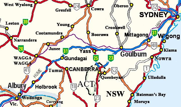
Hume Highway - NSW
Canberra can be accessed by the Hume Highway with connections at Federal Highway (green National Highway 23) and Barton Highway (National Highway 25). It can also be accessed from the south by the Monaro Highway (white National Highway 23
From Wikipedia, the free encyclopedia
New South Wales City and Town Maps
A
B
C
D
E
F
G
H
I
J
K
L
M
N
O
P
Q
R
S
T
U
V
W
Y
New South Wales Maps — Interactive Map, Street View, Weather & News
This page provides an interactive Google map of New South Wales (NSW) with Street View, satellite and terrain views, alongside links to detailed street maps for 4,621 cities, towns and localities across the state. The capital is Sydney and the largest city is Sydney, with a population of approximately 8,072,163 (ABS 2021 Census).
Each locality map page includes an embedded street and satellite map together with live weather where available — current observations with hourly and 7-day outlooks powered by Open-Meteo. Local and world news, editorial location descriptions, and precise GPS coordinates are included where available.
Location data is sourced from Geoscape Administrative Boundaries and verified by coordinates, not name matching alone.