Interactive Map Of Australia
Explore Australia with this interactive map featuring Street View, satellite and terrain views. Our 15,000+ location pages are real-time information hubs — built for travel planning, research and emergencies, including storms, flooding and severe weather events.
Interactive Map of Australia
Map search is available for a limited number of queries per session to manage costs. Be specific — search precisely for best results.
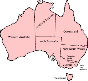
Australian State & Territory Maps
States
Territories
Largest Australian Cities
| Country | Australia |
| Capital | Canberra, ACT |
| Largest City | Sydney |
| Official Language | English |
| States & Territories | 6 states, 2 territories |
| Currency | Australian Dollar (AUD) |
| Latitude | 25.2744°S |
| Longitude | 133.7751°E |
| Population | ~26,500,000 |
| Area | 7,692,024 km² |
| Timezone | Multiple (UTC+8 to UTC+11) |
| Driving Side | Left |
About Australia
Australia unfolds across a continent of stark contrasts, a land sculpted by immense geological forces and the patient hand of time. Vast, ochre deserts shimmer under an almost impossibly blue sky, giving way to rugged mountain ranges that cradle pockets of temperate rainforest and snow-capped peaks in the south. The immense coastline, a sinuous ribbon of sand and rock, meets the cerulean embrace of the ocean, while the tropical north hums with the vibrant life of ancient rainforests and the world's most magnificent coral reef. This is a country where the earth breathes with dry heat and whispers with the rustle of eucalyptus, where rivers, often seasonal in their flow, carve their paths through ancient landscapes. Australia’s climate zones shift dramatically, from arid heartlands to fertile southern plains and the humid embrace of its northern reaches, painting a diverse and awe-inspiring panorama.
The deep history of Australia is etched into the very land, a legacy carried by Aboriginal and Torres Strait Islander peoples for tens of thousands of years, their connection to country profound and enduring. European settlement, beginning in the late 18th century, introduced a new chapter, one that eventually led to Federation in 1901 and the forging of a modern nation. Contemporary Australian society is a tapestry woven from countless threads, a multicultural mosaic that largely congregates along the eastern and southern coastlines, creating vibrant, energetic cities. Yet, the spirit of Australia also resides in the vast, often sparsely populated interior, a testament to the enduring allure of its unique geography and the diverse origins of its people.
The engine of Australia's economy is a powerful blend of natural resources and burgeoning service industries, a dynamic that shapes its global standing. Immense wealth is drawn from the earth through significant mining operations, particularly in the western and northern regions, fuelling exports and infrastructure development. Agriculture remains a cornerstone, with vast tracts of land dedicated to producing wheat, wool, beef, and world-renowned wines, sustaining both domestic needs and international markets. Beyond these foundational sectors, Australia thrives on its growing tourism industry, attracting visitors to its natural wonders and vibrant cities, while robust financial services and a highly regarded education sector contribute significantly to its economic prosperity.
Life in Australia pulses with a distinctive rhythm, a blend of outdoor pursuits and a deep appreciation for simple pleasures. The nation’s sporting landscape is dominated by passionate rivalries in Australian Rules Football, Rugby League, and cricket, while swimming and surf culture permeate daily life, drawing people to the sun-drenched coastlines. This beach culture is intrinsically linked to an emerging outback identity, a fascination with the rugged beauty and resilient spirit of the interior. Culinary experiences in Australia often celebrate fresh, local produce and fine wines, complemented by a vibrant music scene, acclaimed film industry, and a rich literary tradition that captures the unique essence of this island continent.
Latest News: Australia
Loading news…
Australian News
Loading news…
World News
Loading news…
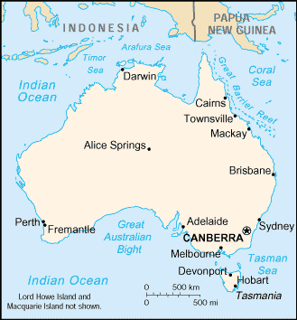
A Map of Australia
Map of Australian States and Territories
From Wikipedia, the free encyclopedia.
Map of Australia, New Zealand and Pacific Islands
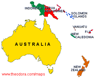
Map courtesy of www.theodora.com/maps used with permission.
Explore Australia — Interactive Maps, Weather & Local Information
This page provides an interactive Google map of Australia with Street View, satellite and terrain views. Each of our 15,000+ Australian location map pages is a self-contained information hub updated in real time. Precise GPS coordinates are sourced from Geoscape Administrative Boundaries (GDA2020), enriched with GeoNames and Australian Bureau of Statistics data.
Live weather is provided through Open-Meteo, including current conditions, an hourly outlook and a 7-day forecast for every location. Local and world news is sourced from multiple feeds — including ABC News Australia — and updated continuously. Wikipedia summaries and editorially written location descriptions are included where available.
Coverage spans all 6 states and 2 territories — from capital cities to remote outback communities and island localities. Location data is verified by coordinates, not name matching alone.
| Page generated | July 2026 |
| Location data | Geoscape Administrative Boundaries (GDA2020); enriched with GeoNames and ABS 2021 Census data |