Interactive South Australia Map
Explore South Australia with an interactive map featuring Street View, satellite and terrain views. Live weather, local news and location details for South Australia — built for travel planning and emergencies.
Map search is available for a limited number of queries per session to manage costs. Be specific — search precisely for best results.
| State | South Australia (SA) |
| Capital | Adelaide |
| Largest City | Adelaide |
| Country | Australia |
| Nickname | The Festival State |
| Latitude | -34.0884 |
| Longitude | 138.3794 |
| Population | 1,781,516 |
| Cities & Towns | 1,910 |
| Area | 983,482 km² |
About South Australia
South Australia unfolds across a vast and varied landscape, its heartland a sun-baked expanse stretching towards the arid centre, where ancient geological formations whisper tales of time. To the west, the Nullarbor Plain offers an unbroken horizon, a stark beauty that draws the eye outwards. Along its southern edge, South Australia is fringed by a coastline of dramatic cliffs and sheltered bays, where the Southern Ocean carves its relentless path, giving way to fertile agricultural belts and rolling hills. Major river systems, though often diminished by the continent’s dry breath, nourish pockets of life, while the Flinders Ranges rise like the weathered spine of the land, their ochre hues shifting with the changing light. National parks protect these diverse ecosystems, from mallee scrubland to rugged coastal heath, offering sanctuaries for unique flora and fauna.
For millennia, the Indigenous custodians of this land understood its rhythms, their connection deeply woven into the fabric of the earth, a stewardship passed down through countless generations. European settlement brought a different kind of ambition, a charting of coastlines and a claiming of territory that began in the early 19th century. South Australia was established as a free colony, distinct from the penal settlements elsewhere, attracting settlers with promises of opportunity and a new beginning. Its colonial history saw the gradual expansion of pastoral runs and agricultural holdings, shaping the pattern of towns and the distribution of people across the landscape. The state’s borders, as they are known today, were largely defined through a process of surveying and administrative division, creating the distinctive shape of South Australia that travellers encounter.
The economic engine of South Australia is powered by a diverse array of industries, reflecting its varied geography and resources. Agriculture remains a cornerstone, with vast plains yielding wheat, barley, and legumes, while the cooler southern regions are renowned for their vineyards producing world-class wines. Mining plays a significant role, extracting valuable minerals from the earth, contributing substantially to the state’s wealth. Beyond these primary sectors, a burgeoning tourism industry capitalises on the state’s natural beauty and unique experiences, drawing visitors from across the globe. Manufacturing and a growing services sector, particularly in the vibrant urban centres, further bolster the economy, ensuring a dynamic and resilient economic base for South Australia.
The cultural tapestry of South Australia is rich and multifaceted, a reflection of its history and its people. The state’s identity is often characterised by a relaxed yet determined spirit, a willingness to innovate and a deep appreciation for its natural surroundings. Major sporting codes, including Australian Rules Football and cricket, command passionate followings, with iconic teams representing the state on national stages. Annual events, from vibrant arts festivals to renowned food and wine celebrations in regions like the Barossa Valley and McLaren Vale, punctuate the calendar. Cultural landmarks, including significant galleries and historical sites, offer insights into the state’s heritage, while the daily life in its cities and regional centres unfolds with a quiet, enduring charm.
City Maps
State Maps
South Australia Road Network Map
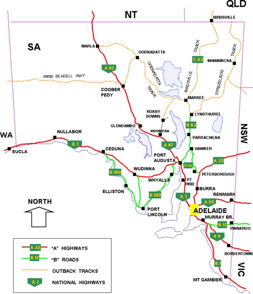
From Wikipedia, the free encyclopaedia
South Australia City and Town Maps
A
B
C
D
E
F
G
H
I
J
K
L
M
N
O
P
Q
R
S
T
U
V
W
Y
South Australia Maps — Interactive Map, Street View, Weather & News
This page provides an interactive Google map of South Australia (SA) with Street View, satellite and terrain views, alongside links to detailed street maps for 1,910 cities, towns and localities across the state. The capital is Adelaide and the largest city is Adelaide, with a population of approximately 1,781,516 (ABS 2021 Census).
Each locality map page includes an embedded street and satellite map together with live weather where available — current observations with hourly and 7-day outlooks powered by Open-Meteo. Local and world news, editorial location descriptions, and precise GPS coordinates are included where available.
Location data is sourced from Geoscape Administrative Boundaries and verified by coordinates, not name matching alone.