Interactive Western Australia Map
Explore Western Australia with an interactive map featuring Street View, satellite and terrain views. Live weather, local news and location details for Western Australia — built for travel planning and emergencies.
Map search is available for a limited number of queries per session to manage costs. Be specific — search precisely for best results.
| State | Western Australia (WA) |
| Capital | Perth |
| Largest City | Perth |
| Country | Australia |
| Nickname | The Wildflower State |
| Latitude | -30.77 |
| Longitude | 117.1821 |
| Population | 2,660,026 |
| Cities & Towns | 1,763 |
| Area | 2,527,013 km² |
About Western Australia
Western Australia unfurls across a vast expanse, its heartland a sun-baked plateau where ancient rock formations stand sentinel. The land breathes with a dry, resilient spirit, transitioning from the scrublands of the interior to the dramatic coastlines that meet the Indian and Southern Oceans. Here, ochre dust mingles with the salty spray, and the light, even on the most overcast days, possesses a peculiar clarity. Inland rivers, often ephemeral, carve their stories into the earth, while national parks offer glimpses of a wild, untamed beauty, a testament to the enduring power of this continent's geology. The sheer scale of Western Australia is humbling, a canvas painted in shades of red, gold, and the deepest blue.
For millennia, this land was the domain of its Traditional Custodians, their deep connection woven into the very fabric of the landscape. The arrival of Europeans marked a profound shift, a new chapter written onto the ancient parchment of Western Australia. Explorers charted its rugged shores, and settlers, drawn by the promise of opportunity, began to shape its destiny. Over time, through exploration, settlement, and the establishment of distinct regions, Western Australia coalesced into the entity it is today, a place where the echoes of the past inform the present.
The economic engine of Western Australia is powered by the earth's generous bounty and the ingenuity of its people. Vast mineral deposits fuel industries that reach across the globe, while fertile plains yield agricultural produce, a testament to human perseverance against the elements. The allure of its pristine beaches and unique natural wonders draws travellers from afar, bolstering a thriving tourism sector. Beyond these pillars, a diverse range of manufacturing and service industries contribute to the state's economic vitality, ensuring its continued prosperity.
The cultural tapestry of Western Australia is as varied as its landscapes, a vibrant blend of heritage and contemporary life. A passion for sport runs deep, with fierce loyalties pledged to AFL teams and the roar of the crowd a familiar sound. Annual festivals and events celebrate everything from arts and culture to the bounty of its renowned food and wine regions, offering a taste of the state's distinct flavour. The rhythm of daily life, from the bustling metropolitan centres to the quiet contemplation of regional towns, reflects a spirit of resilience and optimism that defines the character of Western Australia.
City Maps
State Maps
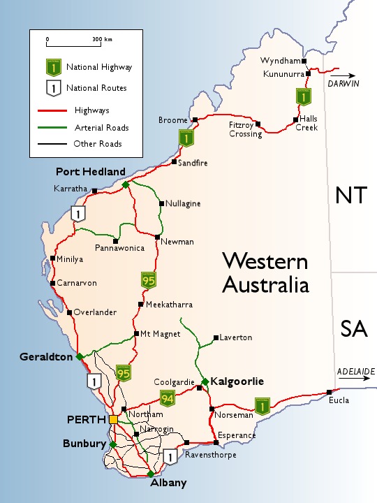
Western Australia Road Network Map
From Wikipedia, the free encyclopaedia
Western Australia City and Town Maps
A
B
C
D
E
F
G
H
I
J
K
L
M
N
O
P
Q
R
S
T
U
V
W
X
Y
Western Australia Maps — Interactive Map, Street View, Weather & News
This page provides an interactive Google map of Western Australia (WA) with Street View, satellite and terrain views, alongside links to detailed street maps for 1,763 cities, towns and localities across the state. The capital is Perth and the largest city is Perth, with a population of approximately 2,660,026 (ABS 2021 Census).
Each locality map page includes an embedded street and satellite map together with live weather where available — current observations with hourly and 7-day outlooks powered by Open-Meteo. Local and world news, editorial location descriptions, and precise GPS coordinates are included where available.
Location data is sourced from Geoscape Administrative Boundaries and verified by coordinates, not name matching alone.