Interactive Victoria Map
Explore Victoria with an interactive map featuring Street View, satellite and terrain views. Live weather, local news and location details for Victoria — built for travel planning and emergencies.
Map search is available for a limited number of queries per session to manage costs. Be specific — search precisely for best results.
| State | Victoria (VIC) |
| Capital | Melbourne |
| Largest City | Melbourne |
| Country | Australia |
| Nickname | The Garden State |
| Latitude | -37.318 |
| Longitude | 144.69 |
| Population | 6,503,491 |
| Cities & Towns | 3,013 |
| Area | 227,416 km² |
About Victoria
Victoria unfurls a varied tapestry of landscapes, from the rugged, windswept coastlines that meet the Southern Ocean to the rolling plains and ancient volcanic plains that stretch inland. The Great Dividing Range, a venerable spine, carves through its eastern reaches, giving rise to snow-capped peaks and deep, forested valleys that cradle pristine national parks. Major rivers, like the Murray and the Yarra, snake their way across the terrain, nurturing fertile agricultural lands and providing vital water sources. The climate shifts with geography, offering cool, temperate zones in the highlands and warmer, drier conditions closer to the interior, painting the land in hues of green and gold throughout the seasons. This diverse natural endowment shapes the very character of Victoria, from its soaring mountains to its gentle, productive pastures.
For millennia, Indigenous peoples were the custodians of this land, their ancient connection woven into the very fabric of its existence. European settlement, beginning in the early 19th century, marked a profound shift, with the establishment of pastoral runs and the burgeoning of settlements that would eventually coalesce into the Victoria we know today. The gold rushes of the mid-1800s brought rapid population growth and economic transformation, fundamentally altering the trajectory of the colony and laying the foundations for its future development. Through periods of colonial administration and eventual self-governance, Victoria evolved, its towns and cities growing organically from the needs of its people and the resources of the land. The shaping of Victoria into a distinct political entity reflects a long and complex history of human endeavour and adaptation.
Victoria’s economy is a robust blend of innovation and tradition, driven by a diverse range of industries that capitalise on its natural and human resources. Agriculture remains a cornerstone, with fertile plains yielding abundant crops and livestock, while the state's mineral wealth continues to be extracted. Beyond the land, a significant manufacturing sector and a thriving services industry, particularly in finance and technology, contribute substantially to its economic vitality. Tourism flourishes, drawn by the state's natural beauty, vibrant cities, and world-class events. Major regional centres and bustling metropolitan hubs form the economic arteries of Victoria, facilitating trade, innovation, and the daily commerce that sustains its people.
The cultural heart of Victoria beats with a vibrant rhythm, a reflection of its multicultural populace and a deep appreciation for arts, sports, and culinary excellence. Its sporting arenas are legendary, hosting passionate crowds for Australian Rules Football, cricket, and other popular codes, with fiercely loyal teams representing the state's competitive spirit. The world-renowned Melbourne Cup and a calendar brimming with festivals and exhibitions draw visitors and locals alike, celebrating everything from artisanal food and wine to avant-garde theatre. Food and wine regions, celebrated for their quality produce and picturesque vineyards, offer a taste of Victoria’s dedication to flavour. Daily life in Victoria is a dynamic interplay between the energy of its urban centres and the serene pace of its country towns, all contributing to a rich and multifaceted identity.
City Maps
State Maps
Road maps of The State of Victoria, Australia. Find the best driving route between Melbourne, Albury-Wodonga, Ballarat, Bendigo, Geelong, Latrobe Valley, Mildura and Shepparton.
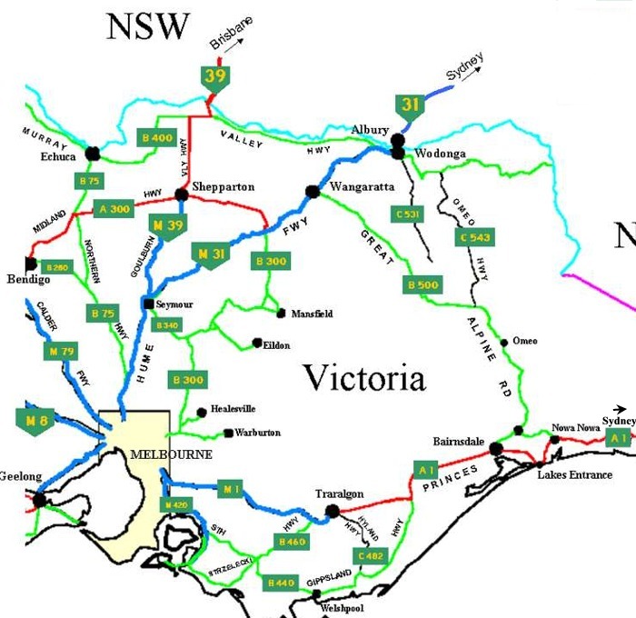
Eastern Victoria Australia Road Network Map
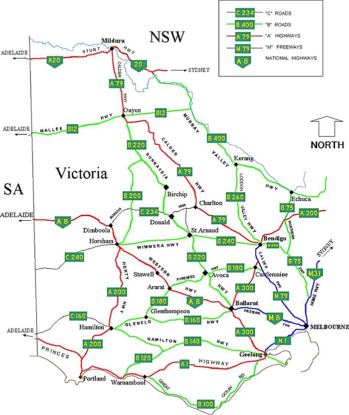
Western Victoria Australia Road Network Map
From Wikipedia, the free encyclopaedia
Victoria City and Town Maps
A
B
C
D
E
F
G
H
I
J
K
L
M
N
O
P
Q
R
S
T
U
V
W
Y
Victoria Maps — Interactive Map, Street View, Weather & News
This page provides an interactive Google map of Victoria (VIC) with Street View, satellite and terrain views, alongside links to detailed street maps for 3,013 cities, towns and localities across the state. The capital is Melbourne and the largest city is Melbourne, with a population of approximately 6,503,491 (ABS 2021 Census).
Each locality map page includes an embedded street and satellite map together with live weather where available — current observations with hourly and 7-day outlooks powered by Open-Meteo. Local and world news, editorial location descriptions, and precise GPS coordinates are included where available.
Location data is sourced from Geoscape Administrative Boundaries and verified by coordinates, not name matching alone.