Interactive Australian Capital Territory Map
Explore Australian Capital Territory with an interactive map featuring Street View, satellite and terrain views. Live weather, local news and location details for Australian Capital Territory — built for travel planning and emergencies.
Map search is available for a limited number of queries per session to manage costs. Be specific — search precisely for best results.
| Territory | Australian Capital Territory (ACT) |
| Capital | Canberra |
| Largest City | Canberra |
| Country | Australia |
| Nickname | The Nation’s Capital |
| Latitude | -35.2179 |
| Longitude | 148.9819 |
| Population | 454,499 |
| Cities & Towns | 153 |
| Area | 2,358 km² |
About Australian Capital Territory
Australian Capital Territory unfolds as a land of rolling hills and broad, open skies, a gentle interior landscape far from any ocean's touch. The terrain here is a tapestry of eucalyptus forests, interspersed with grazing paddocks and the subtle undulations of the Great Dividing Range. Majestic mountain ranges, like those forming the backdrop to its heart, offer breathtaking vistas and a cool, crisp air that speaks of elevation. National parks, such as Namadgi, preserve vast tracts of this natural beauty, revealing ancient rock formations and vibrant wildflowers in spring. The climate zones shift with altitude, offering warm summers and crisp, often frosty, winters, a distinct seasonal rhythm that shapes the land. Major rivers, though often appearing as serene ribbons, are the lifeblood of this inland reach, guiding the eye across the expansive Australian Capital Territory.
The story of Australian Capital Territory is one of ancient stewardship and deliberate creation, a testament to the enduring spirit of place. For millennia, Indigenous peoples knew these lands intimately, their connection woven into the very fabric of the earth, a deep understanding passed through generations. European arrival brought a new chapter, a vision for a centralised national capital, a purpose-built heart for a burgeoning nation. Colonial surveyors and planners meticulously shaped the landscape, transforming pastoral holdings and undeveloped bushland into the ordered design that defines the Australian Capital Territory today. This careful orchestration of nature and human intent has resulted in a unique setting, a place where national aspirations took root in the fertile soil of this inland region.
The economic pulse of Australian Capital Territory beats with a strong emphasis on the service sector, particularly government administration, reflecting its role as the nation's administrative centre. Beyond the corridors of power, a diverse array of industries contributes to its prosperity, with a growing focus on technology, research, and education. Agriculture, though not as dominant as in some neighbouring regions, still plays a role, with vineyards and farms dotting the periphery, offering local produce and distinct regional flavours. Tourism, drawn by its national institutions, natural beauty, and cultural attractions, also forms a significant economic driver, welcoming travellers to explore the heart of the Australian Capital Territory.
The cultural heart of Australian Capital Territory beats with a quiet confidence, a blend of national significance and community warmth. Daily life unfolds with a rhythm that balances the gravitas of its federal institutions with the relaxed pace of a regional centre. Sporting loyalties run deep, with passionate support for teams representing Australian Capital Territory in national leagues, fostering a strong sense of collective identity. Major annual events, from festivals celebrating arts and culture to sporting carnivals, bring vibrant energy to the cities and towns. The region's food and wine scene, influenced by its proximity to fertile agricultural lands and a growing culinary sophistication, offers delightful experiences for residents and visitors alike, showcasing the character of the Australian Capital Territory.
City Maps
State Maps
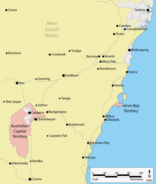
Australian Capital Territory ACT Map
From Wikipedia, the free encyclopaedia
Australian Capital Territory City and Town Maps
B
C
J
M
N
P
R
W
Australian Capital Territory Maps — Interactive Map, Street View, Weather & News
This page provides an interactive Google map of Australian Capital Territory (ACT) with Street View, satellite and terrain views, alongside links to detailed street maps for 153 cities, towns and localities across the territory. The capital is Canberra and the largest city is Canberra, with a population of approximately 454,499 (ABS 2021 Census).
Each locality map page includes an embedded street and satellite map together with live weather where available — current observations with hourly and 7-day outlooks powered by Open-Meteo. Local and world news, editorial location descriptions, and precise GPS coordinates are included where available.
Location data is sourced from Geoscape Administrative Boundaries and verified by coordinates, not name matching alone.