Blue Mountains Photographs
Home > Australian Photos > Blue Mountains Photos
(Click on an image to view a Larger Picture)
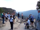
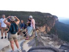
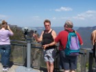
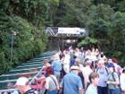
These photos were taken by me while I was on holiday in Sydney Australia in September / October 2004. We were on a tour bus operated by FJ Tours. This tour was of the blue mountains and I can highly recommend FJ Tours. The driver gave us a good expansive narrative relating to the Blue Mountains, to Sydney and Australia at large. They also had a 22 seater mini-coach but we were on a full size touring coach that was air-conditioned with heavily tinted windows which was cool in the hot Australian climate.
- These images are protected by copyright. They may not be copied for use elsewhere.
Blue Mountains
From Wikipedia, the free encyclopedia
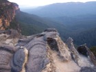
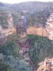
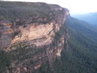
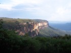
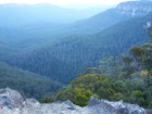
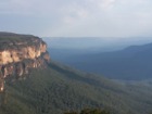
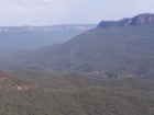
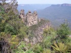
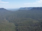
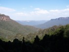
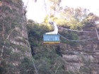
The Blue Mountains of New South Wales, roughly 100 kilometres west of Sydney, are a range of sandstone mountains that reach to about 1200 metres above sea level, and form part of the Great Dividing Range that runs roughly parallel to the east and southeast coast of Australia for thousands of kilometres. Blue Mountains also refers to the City of the Blue Mountains (or Blue Mountains City Council), a local government area within the range. The Blue Mountains take the form of a plateau with deep, rugged gorges of up to 1000 metres. The Blue Mountains cover an area of about 1436 square kilometres (552.9 square miles).
History
The Blue Mountains were thought to be impenetrable by the early settlers of Sydney and were not crossed until 1813, by Blaxland, Wentworth and Lawson. Rather than, like earlier explorers, following the river valleys—only to discover that they were terminated by vertical cliffs several hundred metres high—the trio followed the ridges to reach the plateau. The first crossing of the Blue Mountains has traditionally been regarded as a critical step that opened the west of New South Wales to white settlement: however, modern historians point out that until about the time the mountains were first crossed there was still ample land available closer to the coast: the oft-told tale that the Blue Mountains were a crippling barrier to colonial expansion is largely myth.
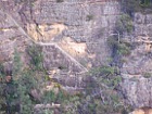
A road crossing the mountains was quickly built using convict labour in the time of Governor Lachlan Macquarie. Coal and oil shale were mined near Katoomba up until after the Second World War.
Geography
The name derives from the bluish tinge the range takes on when viewed at a distance, which is caused by the release of volatile oils from eucalyptus forests. (Most mountains and plains in the forested parts of Australia take on a similar hue: the Blue Mountains were a familiar sight to early British settlers in the Sydney district long before the bulk of the continent was explored by non-native people.)
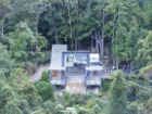
The predominant natural vegetation of the higher ridges is stringybark forest; heath-like vegetation is present on the cliffs. The sheltered gorges often have a temperate rainforest. There are also many hanging swamps with button grass reeds and thick, deep black soil. The famous Wollemi Pine, a relic of earlier vegetation of Gondwana is found in the of the remote and isolated valleys of the Blue Mountains.
Many Bushcare Groups carry out bush regeneration to restore and protect the beautiful surrounding bushland areas on Public lands within the City in the Blue Mountains.
The climate varies with height. At Katoomba (1010 metres) summer daytime temperatures are usually in 20s with a few days extending into the 30s (Celsius). Night time temperatures are usually in the teens. In winter the temperature is typically about 12 or 13 degrees in the day with minus 3 or so on clear nights and 2-3 on cloudy nights. There are 2-3 snowfalls per year. Rainfall is about 48 inches with many misty days.
The main natural disasters to afflict the area are bushfires and severe storms. In recent years the lower mountains has been subjected to a series of bushfires which have caused great loss of property but relatively little loss of life. The upper mountains have not had a major fire for some decades but this is probably simply a matter of time. A program of winter burning seems to have been quite successful in reducing fires in the upper maintains.
City of the Blue Mountains
The City of the Blue Mountains (referred to as "The City Within The World Heritage National Park") consists of a ribbon of close or contiguous towns which lie on the rail and road link between Penrith (a western suburb of Sydney) and Lithgow (a coal mining town). There is a frequent electric train service which integrates into the suburban rail network of Sydney, CityRail. The road is mostly dual carriageway but is relatively slow because of the urban development and hilly terrain.
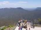
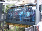
The lower mountains (Glenbrook, Warrimoo, Winmallee, Blaxland, Springwood and Faulconbridge and Woodford) tend to be dormitory suburbs for Sydney. This is also the case for the upper mountains (Hazelbrook, Lawson, Wentworth Falls, Leura, Katoomba, Blackheath and Mt Victoria) but to a lesser extent. Tourism is important in the upper mountains. Jenolan Caves, a spectacular series of limestone caves is often included with the Blue Mountains and this lies about (60 -100 km ??) to the south west of Katoomba.
I used a Kodak DX6490 4.0 mega pixel digital camera to photograph these images from the Blue Mountains.